Tag Archives: Indians

Revisiting the Delaware Moors, Part I: The Legends

I was a teenager when I first heard someone use the term Moor to refer to a member of central Sussex County’s multiracial community, which claims and celebrates Native American ancestry. “Moor?” I asked, confused, thinking of northern Africa. “What’s that mean?” The response was quipped like a punchline: “More nigger than anything.”

I didn’t know it at the time, but C. A. Weslager had mentioned a similar tongue-in-cheek explanation of the odd label in his book Delaware’s Forgotten Folk: The Story of the Moors and Nanticokes, published in 1943. During that era of segregation, such a remark was not only a crude joke, but relegated the target to the second-class colored community. Since before the Civil War, Delawareans who claimed Indian ancestry had been accused, by both whites and blacks, of being nothing more than blacks seeking special treatment.

But the local term Moor, as an ethnic label, doesn’t seem to have originated as a racial slur. In fact, the so-called Delaware Moors identified themselves as Moors as early as the 19th century, if not earlier. But what’s the story behind the name?

Scharf’s History of Delaware, published in 1888, offers the following description of the group in question in Sussex County:

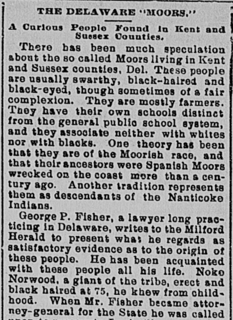
In the hundreds of Indian River, Lewes and Rehoboth and Dagsborough are a numerous class of colored people, commonly called yellow men, and by many believed to be descendants of the Indians, which formerly inhabited this country. Others regard them as mulattoes and still others claim that they are of Moorish descent. From the fact that so many of them bear the name of Sockum, that term has also been applied to the entire class of people. Of their genealogy, Judge George P. Fisher said:

“About one hundred and fifty years ago a cargo of slaves from Congo River was landed at Lewes, and sold to purchasers at that place. Among them was a tall, fine-looking young man about five and twenty years. This man was called Requa, and was remarkable for his manly proportions and regular features, being more Caucasian than African. Requa was purchased by a young Irish widow, having red hair, blue eyes and fair complexion. She afterwards married him. At that time the Nanticoke Indians were still quite numerous at and near Indian River. The offspring of Requa and his Irish wife were not recognized in the white society, and they would not associate with the negroes, and they did associate and intermarry with the Indians.

“This statement was made on oath of Lydia Clark, at Georgetown, in 1856, in the trial of the case of the State against Levin Sockum for selling, contrary to law, powder and shot to one Isaiah Harman, alleged to be a free mulatto. The question upon which the case turned was whether Harman really was a free mulatto, and the genealogy of that race of people was traced by Lydia Clark, then about eighty-seven years of age, who was of the same race of people.

“The court was so well convinced of the truth of Lydia’s testimony that Sockum was convicted of the charge preferred against him.

“This race of people are noted as peaceable, law-abiding citizens, good farmers, and are known as Moors, but without any foundation. The name Requa or Regua is now handed down as Ridgeway.”

The exclusiveness spoken of continues to the present time. This class of people maintains its separate social life (so far as it is possible to do so) seldom intermarrying with the negroes or mulattoes, and support separate churches. The number in the county is diminishing, owning to removals and natural causes but enough remain to make it a distinctive element.

Interestingly, Fisher wrote an article for the Milford Herald in 1895 which offers a somewhat different version of the story (which was picked up by numerous newspapers across the country around that time). In this slightly later version, it is the Irish lady who was named Regua, and she purchased a slave of “dark ginger-bread color, who claimed to be a prince or chief of one of the tribes of the Congo River…” Though most of the details are the same, the few differences raise questions about Fisher’s reliability, as in each case he is supposedly recounting Lydia Clark’s testimony.

The Roanoke Times, July 27, 1895

The Roanoke Times, Virginia; July 27, 1895

The article from 1895 might be more valuable for Fisher’s recollections from his own childhood, particularly of Noke Norwood, said to be Lydia Clark’s brother:

When I was a boy and young man, the general impression prevailing in the several parts of this State where this race of people had settled was that they had sprung from some Spanish Moors who, by chance, had drifted from the southern coast of Spain prior to the Revolutionary War and settled at various points on the Atlantic Coast of the British colonies; but exactly where and when, nobody could tell.

This story of their genesis seemed to have originated with, or at any rate, was adopted by the last Chief Justice, Thomas Clayton, whose great learning and research gave semblance of authority to it, and, like almost everybody else, I accepted it as the true one for many years, although my father, who was born and reared in that portion of Sussex County where these people were more numerous than in any other part of the State, always insisted that they were an admixture of Indian, negro and white man, and gave his reason therefore–that he had always so understood from Noke Norwood, whom I knew when I was a small boy. Noke lived, away back in the 20’s, in a small shanty long since removed, situated near what has been known for more than a century as Sand Tavern Lane, on the West side of the Public Road and nearly in front of the farmhouse now owned by Hon. Jonathan S. Willis, our able and popular Representative in Congress.

I well remember with what awe I contemplated his gigantic form when I first beheld him. My father had known him as a boy, and I never passed his cabin without stopping. He was a dark, copper-colored man, about six feet and half in height, of splendid proportions, perfectly straight, coal black hair (though at least 75 years old), black eyes and high cheek bones.

Fisher was born in 1817, so according to him, a legend concerning Spanish Moors settling on the coast prior to the Revolution was widely known in Delaware during his youth — say, 1820s – 1840. This is important, because Clark never actually said the word Moor in her testimony, and it’s difficult to determine when Delawareans started using the word as an ethnic label.

In 1898, William H. Babcock visited the Indian River community and wrote an article entitled “The Nanticoke Indians of Indian River, Delaware,” which was published in American Anthropologist the following year.

There are two remnants of Indian population in eastern Delaware, not far from the coast — the so-called Moors of Kent county and the more southerly Nanticokes on Indian river in Sussex county.

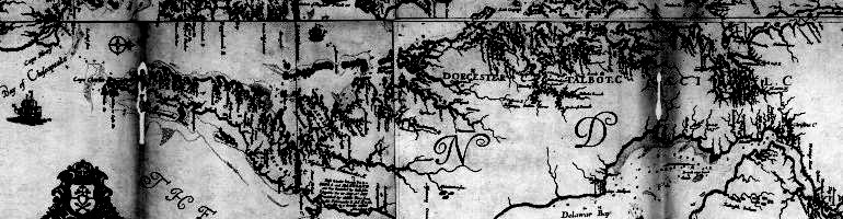
Of the former I can speak by report only, not having visited them. According to an old legend they are the offspring of Moors shipwrecked near Lewes; a more romantic version gives them only one Moorish progenitor — a captive prince who escaped from his floating prison and found wife and home among the half-Indian population alongshore. There are said to be two or three hundred of these people, clustering mainly around Chesholm, a hamlet and railroad station a few miles south of Dover. The Philadelphia Press for December 1st, 1895, presents a series of portraits which, if accurate, go far to sustain the contention of the Nanticokes that there is not much in common between the two peoples; but their intercourse is too slight and infrequent for their judgment to be conclusive. They consider the Chesholm people to be a mixture of Delaware Indians with some Moorish or other foreign strain. According to their tradition the Nanticoke and Delaware tribes were often at war in the old time, and even yet there would seem to be a barrier of rather more than indifference between them.

Babcock’s distinction between Moors in Kent County and Nanticokes in Sussex County is interesting, though not strictly accurate. Barrier or not, the communities at Cheswold and Indian River were connected by marriage, and shared many of the same surnames (not to mention the same folklore), before 1898 (and probably before the Civil War). Weslager’s later research among the Cheswold Moors revealed that some claimed Nanticoke, and even Pocomoke, ancestry, remembering the specific creeks in Sussex County and Maryland that their grandparents had lived by. And, of course, the members of the Indian River community were known as Moors, too. However, it’s a matter of fact that the Indian River people legally established a new Indian tribe in the form of the Nanticoke Indian Association, while the people at Cheswold continued to call themselves Moors long afterward (though today there is a “Lenape Indian Tribe of Delaware” based in Cheswold). Is this important? Maybe, maybe not.

In his History of the State of Delaware, published in 1908, Henry Clay Conrad made a rather sensational statement in a section about Kent County:

James Green another large owner of land in Duck Creek Hundred owned a large tract in Kenton known as “Brenford,” Philip Lewis took up several large tracts adjoining these and extending from a small settlement known as the “Seven Hickories,” on the road from Dover to where the village of Kenton was eventually built on his land; and one thousand acres adjoining the settlement of “Seven Hickories” were owned by Moors who came to the Hundred direct from Spain in 1710, and who settled in a village known as Moortown on the Dover-Kenton road.

In 1785 these Moors owned large estates and had a prosperous and thriving community. John and Israel Durham were leading members of this settlement. They and their descendants refused to mingle with their white or black neighbors and have maintained to this day their pure Moorish blood. Several families now remain in this section as direct descendants of these Moors.

Conrad’s account seems to be an exaggerated interpretation of a much more reasonable passage in Scharf’s history of Kenton Hundred:

West of the town of Moorton are a class of people who claim that they are original Moors. At one time they owned over a thousand acres between Seven Hickories and Moorton. They claim to have settled here about 1710. In 1785 there were several families owning quite large estates, among whom were John and Israel Durham. They have always lived apart from both white and colored neighbors, and have generally intermarried, and steadily refused to attend the neighboring colored schools. In 1877, Hon. Charles Brown, of Dover, gave them ground and wood for a building near Moore’s Corner, and since that time they have maintained a school there at their own expense. There are about fifteen families remaining.

The information published by Scharf is surprisingly specific. I.e., in the 1880s, the residents of the community west of Moorton claimed Moorish ancestry, and furthermore claimed that their ancestors had settled in the neighborhood circa 1710. These claims are fairly subdued compared to the other legends involving shipwrecks and African princes. This doesn’t make them true, but it does make them difficult to ignore; the researcher feels compelled to take a closer look.

To be continued…

– Chris Slavens

1 Comment

Filed under Delaware, Delaware history, Delaware Moors, Kent County (DE), Nanticoke Indians, Sussex County

Nanticoke Indian Surnames

Every word in the title of this post is inappropriate, to an extent. The following names are not all Nanticoke names, necessarily. They may or may not technically be surnames. And, of course, we all know that Native Americans shouldn’t have been called Indians. A more accurate title might be: “Family names associated with native peoples of the Delmarva Peninsula in the 17th and 18th centuries.”

Note that the following names are not associated with the modern Nanticoke Indian Association. Surnames like Clark and Harmon are certainly deserving of attention, but they’re also of European origin. I wish to briefly comment on a few surnames or family names that appear in historical records, definitely linked to local Indians, and definitely rooted in their language.

Asquash (or Ashquash)

Ashquash was a son of the Nanticoke emperor Unnacokasimon, who probably died in the 1680s. Unnacokasimon’s brother, Opeter or Ohopperoon, succeeded him following his death, but the English authorities believed the old emperor had been poisoned and viewed the brother as a usurper. His fate is unclear. Ashquash was emperor in 1705, but left the Eastern Shore in 1713 to live among the Susquehanna Indians.

In 1725, a William Asquash living in Chicacoan Town was described as “the late Emperor’s son.” In other records, the name was sometimes spelled Ashquash. The combination of an English first name and his father’s name is interesting; perhaps he wanted a surname to be more like his white neighbors. However, his relationship to others who apparently used the name Asquash as a surname is unclear. In 1742, Abraham and Jemmey Asquash were living in Chicacoan Town, while in 1757, a petition asking the provincial government to recognize George Pocatehouse as the emperor was signed by John Asquash, Nancy Ashquash, Molley Ashquash, Moses Ashquash, and William Ashquash.

The name is a fairly common word in Algonquian languages, referring to similar plants such as pumpkins, cucumbers, melons, etc., and is the basis for the English word squash. A much earlier example of its use as a name comes from Connecticut, where, in 1644, an Indian named Ashquash murdered an English servant.

Unfortunately, the name seems to have left the peninsula, and/or died out. I’ve searched in vain for records of later Asquashes or Ashquashes.

Cohonk

Cohonk, like Asquash, is an Algonquian term found beyond the Delmarva Peninsula. It referred to the honking of Canadian geese, and was also associated with the coming of winter or the passage of a year. In 1742, a James or Jamey Cohonk testified about the Wimbesoccom event; apparently he was from Chicacoan Town, making him a Nanticoke. He and other Cohonks were involved in the dispute about whether the provincial government should recognize Peter Monk or George Pocatehouse as the emperor in the late 1750s. Like Asquash, the name Cohonk seems to disappear from the records after that period.

Puckham or Puckum

The surname Puckham or Puckum is a bit problematic, because it could be a variation of the English surname Peckham, and is rather common. (A search of Ancestry.com for “puckham” yields nearly two million records, including spelling variations.) However, in the 1670s, there was a 1,500-acre Indian settlement on the east side of the Nanticoke River and on the north side of Barren Creek known as Puckamee. Furthermore, in 1682, an Indian named John Puckham married Jone Johnson, a free “negro” woman, in Stepney Parish, Somerset County. Stepney Parish covered the area between the Nanticoke and Wicomico Rivers. An excellent article at Native American Roots explains the view that Puckham may have been derived from Puckamee, which meant “a place to source red ochre.” Whatever its origins, the surname Puckham or Puckum has generally been associated with blacks since the colonial era.

Hop

Hop is not a name, per se, but it seems to have been part of many names. Unnacokasimon’s brother was Ohopperoon; John Chinehopper was a leader of the Nanticokes in 1742; Tom Hoppington was a Nanticoke from Chicacoan Town in 1742, and Hopping Sam was a chief of the Locust Neck Indians (or Choptanks) in 1742. It seems safe to assume that these names shared a common root.

– Chris Slavens

Leave a comment

Filed under Delaware history, Maryland history, Nanticoke Indians

The Sockum Family and the Nanticoke Indians: Further Research

In March of 2014 I wrote an article entitled “Sockum and the Nanticokes of Broad Creek,” which summarized genealogical and historical data connecting the Sockum family to the Nanticoke Indians who lived around Broad Creek in the 18th century. The information raised more questions than it answered; although many Sockums appeared in early records — even as early as 1756 — it’s difficult to connect them to each other.

Although I haven’t uncovered any major new information (i.e., indisputable evidence of a Sockum-Nanticoke connection), with the annual Nanticoke Indian Powwow coming up in a few weeks, now is a perfect time to offer a somewhat tentative interpretation of some of the early Sockum information which might help us to better understand this family’s history. I want to make it clear that I’m engaging in speculation here — very informed speculation, based on primary sources like census and tax records — but speculation nonetheless.

I. James and Rachel Sockam, 1756 – 1757, near Rewastico Creek

The story begins with James Sockam and his wife, Rachel, who were living in the household of James Weatherly in Nanticoke Hundred, Somerset County, Maryland, in 1756. The following year, they had their own household in the same hundred. Lest today’s reader wrongly assume that this location was in today’s Somerset County, a word of explanation is in order. At that time, there was no Wicomico County, and Somerset and Worcester Counties included more than half of today’s Sussex County, Delaware. Nanticoke Hundred was the area between the Nanticoke and Wicomico Rivers, roughly. Somerset stretched northward along the west side of Stage Road to the site of present-day Laurel on Broad Creek.

Although the fairly large Nanticoke Hundred included (in today’s terms) Quantico, Hebron, parts of Salisbury, Delmar, and half of Laurel, land records pertaining to James Weatherly and other members of the Weatherly family help us to narrow it down. In 1716, a 136-acre tract of land named Weatherles Marshes was described as “lying and being in Somerset County on the southernmost side of Nanticoak River and on ye north side of Rowasticoe Creek…” The tract was patented to James and William Weatherly in 1728. In 1755, a 75-acre tract named Weatherly’s Lot was surveyed for James Weatherly, and was described as “Begining at a Marked Read Oak standing on the North side of Rewastico Creek back in the woods and on the East side of the main Road that leads from Rewastico Mill to Barren Creek Mill…” Other surveys pertaining to the Weatherly family point at the same general area: East of the Nanticoke, north of Rewastico Creek, and south of Barren Creek, roughly in the neighborhood of Hebron.

The record for 1757 tells us little more. James “Scokem” was now a head of household, but hadn’t moved far; James Weatherly’s household number was 163, while Sockam’s was 167. No household members other than Rachel are listed, but they wouldn’t have been unless they were at least 15 years old, so the couple may have had children.

The will of James Weatherly, Sr., dated 1761, mentions several slaves by their first names, as well as oddly referring to Joseph Weatherly as his “friend,” but does not mention the Sockams or offer any clues as to why they were dependents in his household just five years earlier. The place name Cedar Landing appears in the will a couple of times.

So it seems that I was wrong two years ago when I stated that James and Rachel Sockam probably lived in what is now Little Creek Hundred, Sussex County, Delaware. Between 1756 and 1757, at least, they lived near Rewastico Creek. The difference isn’t major — the two neighborhoods are only separated by a few miles, maybe a dozen, probably fewer than twenty — and doesn’t affect the theory that James Sockam might have been a Nanticoke Indian, since the territory in question was still Nanticoke territory, and wasn’t far from Chicacoan Town. However, it was a bit far from Wimbesoccom Creek, later known as Sockum Creek. I still believe that there must be a connection between this Nanticoke Indian place-name and the Sockum surname, but obviously the connection is a mystery at this point, and the fact that the earliest known Sockum didn’t live near Wimbesoccom raises even more questions.

II. Sockums in Dagsborough Hundred, 1770s – 1800

James — or possibly a son named James — next appears in “Dagsberry” Hundred in 1777, along with an Isaac Sockom. Both were considered colored. James appears in records throughout the 1780s and 1790s, always in Dagsborough Hundred. In 1784, a “widow Sockam” is mentioned. In 1795-1796, a Lowder or Loweder Sockum was taxed, also in Dagsborough Hundred. At that time, the hundred included the area east of Broad Creek, south of Indian River, and west of Vine Creek, including part of the future Gumborough Hundred. Interestingly, it also included the site of the old “Indian River Indian” reservation known as Askesky. The reservation lands were no longer owned by Indians in 1777, but it’s certainly possible that remnants of the local Indian tribes still lived nearby — and the Sockums in question may have been some of them.

These Indians (or part Indians) had consciously chosen to stay behind when most of the Nanticokes migrated north a few decades earlier. Why? We can only speculate. Maybe they had already mixed with whites and/or blacks and weren’t really considered part of the tribe. Maybe they preferred to adopt European culture, even if that meant forsaking much of their heritage and living as mulattoes. Maybe they just couldn’t bear to leave their homeland.

There is no proof that James Sockam was a Nanticoke Indian, or even part Indian. However, he certainly wasn’t white. My personal theory at this time is that he was at least part Nanticoke, probably with white and/or black blood, making him “colored” in the eyes of his white neighbors. His colored descendants — whether considered mulattoes or Negroes — would have naturally been more likely to marry blacks than whites due to the attitude of the times. Yet they also would have been likely to preserve stories of Indian ancestry if, in fact, they had any. If this was the case, then we should expect later Sockums to remember that heritage — which is exactly what happened in at least two branches of the family (see Section III).

The gap between 1757 and 1777 might have something to do with the resolution of the boundary dispute between Maryland and Pennsylvania. A resident of the Dagsborough Hundred area prior to 1775 or thereabouts wouldn’t have appeared in any Sussex County records, since the territory was still claimed by Worcester County, Maryland.

III. Sockums in Sussex County, 1800 – 1820s

The name James Sockum (with spelling variations) appears in census records for 1800, 1810, and 1820:

1800: James Socom, Dagsborough Hundred, 4 free persons in household

1810: James Sockem, Little Creek Hundred, 8 free persons in household

1820: James Soccomm (or Soccaum; spelling unclear), Dagsborough Hundred, 2 foreigners not naturalized

These records raise more questions than they answer. Although each record indicates that the entire household was non-white, the connection to Little Creek Hundred is a bit confusing. It’s also unclear whether we’re dealing with one man named James Sockum, or more. With records spanning 1756 through 1820 — a period of 64 years — it seems certain that there were at least two. But was the James Sockam living in Dagsborough Hundred in 1820 the same man who was living there in 1777? Probably, but we can’t be certain.

The Little Creek Hundred record might be explained by the will of Levin Thompson, dated 1804 (with additions as late as 1810). Thompson was a free black who settled in Little Creek Hundred in the 1790s. He became rather wealthy and is an important figure in the history of the Laurel area, and may also be important in the history of the Sockum family. In 1801, Thompson was taxed in Dagsborough Hundred (where he also owned land), and apparently he had purchased 80 acres from James Sockam, though I’ve yet to find the deed. In his will, he left “the place where James Sockam formerly lived” to his son, “Clemmon.” It’s not entirely clear whether he was referring to land in Little Creek Hundred or Dagsborough Hundred. However, in 1817, Clement Thompson sold Levi Hopkins an 89-acre parcel of land in Dagsborough Hundred, which was described as “Beginning at a marked white oak standing on the north side of Shelah’s Branch between James Sockums and Ezekiel [Mearres?]…” Perhaps this parcel included the 80 acres his father had purchased from James Sockum years earlier. Assuming that Shelah’s Branch was an early name for Shoals or Shields Branch, the location was tantalizingly close to the site of the old Indian reservation, as well as Wimbesoccom Neck.

My personal theory at this time is that the records from 1777 through 1820 all referred to the same man, who may have been the son of the James Sockam who lived near Rewastico Creek in the 1750s. This second James Sockam/Sockum was considered colored, probably had at least six children, and probably died in the 1820s.

IV. Sockums in Sussex County, 1820s – 1880s

Between 1821 and 1850, four Sockum households were established in Sussex County, headed by men close enough in age to have been brothers, although there is no proof of that. In fact, their relationship to each other is unknown. But, since I’m speculating, let’s consider the possibility that all four were James Sockam’s sons.

  1. William Sockum was born between 1795 and 1806. In 1830, he was a “Negro” head of household in Broad Creek Hundred (which included the future Gumborough Hundred at that time) with a wife and a daughter under the age of 10. He might have moved away and died in Philadelphia in 1846; further research is needed.
  2. Levin Sockum was born in 1807, and was a head of household in Indian River Hundred by 1840. He had many children, and is the best-known Sockum for being convicted of selling ammunition and gunpowder to a mulatto in the 1850s, despite the buyer’s claim to be an Indian rather than a mulatto. The story of the trial has been told in many sources, notably Delaware’s Forgotten Folk by C. A. Weslager, so I won’t go into further detail here. His neighborhood was nicknamed Sockum or Down Sockum. Levin moved to New Jersey in the early 1860s, changed the family name to Sockume, and died in 1864. Levin’s branch of the family insisted that they were Indians, not mulattoes or Negroes.
  3. Elisha Sockom was born between 1805 and 1816, and was a head of household in Dagsborough Hundred in 1840. He was described as colored, and had three or four children at the time. He appears to have moved to Camden County, New Jersey, where records suggest that he may have been a few years older. An 1880 census record and his death certificate state that he was born in 1794.
  4. Isaac Sockum was born circa 1811, and was a head of household in Broadkill Hundred by 1850. He was described as a mulatto. He and his wife, Louise or Louisa Sammons, had several children. Interestingly, one son was named James. Another, Stephen, is mentioned in Delaware’s Forgotten Folk, and reported that Isaac had claimed that the family was descended from a white man who married an Indian chief’s daughter. Isaac died in Milton in 1894 at the age of 83. At one time, the site of his farm was known as Sockumtown.
Levin Sockum(e), 1807 - 1864

Levin Sockum(e), 1807 – 1864

Another Sockum of unknown origin from this period is a 41-year-old Stephen Sockum who died in 1850 and was buried in the Bethel Colored Burial Ground in Philadelphia, indicating that the Sockum family’s connection to Philadelphia and/or Camden County, New Jersey, existed before Levin moved there in the 1860s.

Yet another person of interest is Ann Sockam, who married Josiah Miller in Kent County, Delaware, in 1849. Although I haven’t done any research on this couple, it’s worth noting that Cheswold, Kent County, was (and is, to an extent) the home of a multiracial community of so-called Moors, which is known to have been connected to the similar community in Sussex County which founded the Nanticoke Indian Association. Additionally, there was a neighborhood named Sockum near Felton in the mid-19th century.

Of course, we can’t be certain that any of these individuals were siblings, but it seems likely that they were closely related. Names like James (for example, Levin’s son Levin James Sockum), Isaac, and Stephen appear often enough for a blood connection to be logical. So why did they all live so far apart? This is a mystery, especially since my theory holds that all had roots in Dagsborough Hundred, and in the original Nanticoke territory prior to that. One possibility which would require quite a bit of research to investigate is that the men married into other multiracial families living in smaller “Moor” communities which preceded the larger and better-known communities in Indian River Hundred and Cheswold. Isaac’s settlement in Broadkill Hundred may have had more to do with job opportunities; as a ship’s carpenter (in 1880), there were only so many places to work.

V. Thoughts on the Sockum Family’s Indian Heritage

The fact that both Levin and Isaac Sockum — who may or may not have been brothers — told their children stories about Indian heritage suggests that there was truth behind those stories. If they were brothers, and if their father was James Sockam of Dagsborough Hundred, and if his father was James Sockam of Rewastico Creek, then they were separated from the Nanticoke era — i.e., the reservations at Chicacoan and Broad Creek, and the Wimbesoccom event, and the exodus beginning in the late 1740s — by only a couple of generations. They thought of their Indian heritage the way that today’s millennials think of the Great Depression; they hadn’t experienced it directly, but it was much more than some distant myth.

The specific details of that heritage, of course, are very unclear. One problem with Isaac Sockum’s claim that a white man married the daughter of an Indian chief is that it doesn’t explain the surname; if Sockum is a Nanticoke name, then it’s highly unlikely that an Englishman would have adopted it or passed it on to his heirs. It’s more likely that an Englishman fathered illegitimate children with an Indian woman, and they wound up with an Indian surname. Or, a freed black slave with no surname married an Indian woman, and adopted an Indian name.

Another problem, though it’s a very minor one, is that the name Sockum isn’t connected to any known Indian individual in any historical sources. Maryland records include a number of 18th-century Nanticoke surnames, such as Asquash, Coursey, and Puckum, but neither Sockum nor any similar term appears in those records (of course, Sockum and Puckum are somewhat similar, but no link between the two has been found). However, since Wimbesoccom Creek was certainly a Nanticoke name, and it was later shortened to Sockum Creek, I think it’s safe to assume that the surname was also of Nanticoke origin.

Lower Sussex County, 1796.

Lower Sussex County, 1796

It’s interesting — but possibly a meaningless coincidence — that Sockum sounds similar to the Algonquin term sachem, which means chief or emperor, and that when the Nanticokes and other tribes held their famous powwow at Wimbesoccom in 1742, they claimed that they had gone there to elect an emperor. Could it be that the site was traditionally used by the tribe to meet and choose emperors? I tend to doubt it (I think the tribes met there in 1742 because it was conveniently located between the reservations at Broad Creek and Askesky, and was on the outskirts of the swamp), but I mention the possibility for the sake of thoroughness.

VI. Avenues for Further Research

The subject of the roots of the Sockum family is far from closed, and there are a number points which deserve further research, such as:

  1. The exact location of James Weatherly’s plantation near Rewastico Creek, and an explanation for why James and Rachel Sockam were living in his household in 1756. There is at least one reference to a tract of land named Sockum located in this general area; finding more information about it could be helpful.
  2. The meaning of Wimbesoccom and Sockum in the Nanticoke language. Although Nanticoke is considered a dead language, clues might be found in other Algonquin languages. These names were not just random combinations of sounds; they meant something to the people who used them in and prior to the 1750s.
  3. The presence of Sockums in New Jersey and/or Philadelphia in the early to mid-19th century. It seems clear that they moved there from Sussex County, but when? And why?
  4. The presence of Sockums in Kent County, Delaware, as well as the fact that there was a neighborhood named Sockum near Felton. When did the name begin to appear in records?
  5. More information on William Sockum and Elisha Sockom, who may have been part of the early migration to New Jersey and/or Philadelphia.
  6. More information on the spouses of the Sockums, and their ancestry.

– Chris Slavens

15 Comments

Filed under Delaware history, Maryland history, Nanticoke Indians, Sussex County

Additions to the bookshelf, and a shout-out

A few days ago I received a surprise gift from my brother: Copies of A Brief Account of the Indians of Delaware by C. A. Weslager, and History of Lewes, Delaware, and Vicinity by Virginia Cullen, which he stumbled upon in an upstate antique shop.

The former is a 31-page pamphlet published for younger readers in 1953, but this is no vague, babyish text about wigwams. Even two decades after his death, Weslager remains the authority on the original Delawareans, and this early work not only paints a picture of their daily lives, but includes specifics about different tribes, including the locations of some of their villages.

A Brief Account of the Indians of Delaware, Weslager

The book about Lewes is a bit longer, 78 pages, and was published by the Daughters of the American Revolution in 1956. The format reminds me of another local history book, Folklore of Sussex County, Delaware by Dorothy Pepper, with sections of a few paragraphs or less featuring a particular era, individual, landmark, etc. The book includes local folklore, and concludes with a guided tour of the community with information about numerous historic buildings.

History of Lewes, Delaware, and Vicinity

Both are the sorts of books that one typically finds in noncirculating collections in local libraries. Many of Weslager’s books, in particular, can be very difficult to find, and are treasured by collectors.

While I’m at it, I’d like to give a brief shout-out to Mitsawokett, probably the best online source of information about Native Americans in Delaware from prehistoric times through the present. The site features information ranging from casual speculation to authoritative primary sources, and links to numerous other sites of interest. Someone recently added a couple of my articles about the Nanticoke Indians, causing Mitsawokett to become the top referrer of visitors to this blog (discounting search engines and social media), which I greatly appreciate.

– Chris Slavens

Leave a comment

Filed under Books, Delaware, Delaware history, Sussex County

The Nanticokes’ Last Stand

The following article and map were first published in the Laurel Star in May 2015.

The Nanticokes’ Last Stand
by Chris Slavens

With about 800 houses on the National Register of Historic Places and more than a dozen historic churches in and around the town, Laurel is the kind of place where the past is not only remembered, but celebrated. Many local families can trace their roots back to the 18th century, and some still live on land cleared by their distant ancestors when the Delmarva Peninsula was a wild frontier. Yet one of the most significant and fascinating events in the area’s history is also one of the least known, possibly because it took place when the area was claimed by Maryland.

Long before Barkley Townsend founded a town on the south side of Broad Creek and named it after the beautiful laurel bushes growing along the creek’s banks, the Nanticokes thrived here. Their territory stretched from the Chesapeake Bay to the vast cypress swamp in the center of the peninsula, and was home to at least ten villages. Captain John Smith visited the tribe in June of 1608, and noted that they were rich in furs and shell money, and were “the best Marchants of all other Salvages.”

In the following decades, the tribe listened to reports of European expansion, as the Dutch and Swedes settled in the northeast, and the English spread out from the western shore into Accomack and Choptank territory, and beyond. Attempts to resist ended badly. It was with this in mind, perhaps, that Unnacokasinnon, “Emperor of Nantecoke,” signed a peace treaty in 1668. The treaty laid out several rules for the Nanticokes; among them, that they would be required to lay down their weapons if they crossed paths with Englishmen in the woods. Unnacokasinnon also promised to “deliver up” the neighboring Wicomisses, who were his subjects. A Wicomiss man had recently killed an English captain, possibly to avenge the death of his wife. The Wicomisses were subsequently destroyed.

In 1698, the Maryland legislature established a large reservation on Chicacoan Creek, but a few years later, at about the time that the town of Vienna was established nearby, most of the Nanticokes moved up the river to Broad Creek. Whether they reclaimed an old village, moved into an existing one, or established a new one is unclear. It seems that the move was prompted by a combination of English harassment and depleted resources. The legislature, reluctant to provoke the tribe, decided to create a second reservation rather than force them to leave. The Nanticoke village on Broad Creek became known as Broad Creek Town, and its residents were sometimes called the Broad Creek Indians. At that time, the area was part of Somerset County (Worcester and Wicomico Counties did not yet exist), and would not be ceded to Sussex County for nearly seventy years.

During the next three decades, many English settlers were granted land in the surrounding area. Most of them were tobacco planters from Maryland and Virginia, drawn to northern Somerset by affordable land. At that time, the territory east of Broad Creek Town was part of the immense Pocomoke Swamp. In addition to clearing the land of trees, the settlers had to drain it, which was accomplished with a network of ditches.

Nanticoke territory, 1742

As more and more land was cleared and cultivated, the Nanticokes began to feel cornered. For generations they had lived in long-term villages along the coast, rivers, and creeks for most of the year, and periodically moved inland to hunt. Now they were more or less confined to their two reservations. Dishonest traders’ use of alcohol to intoxicate them and trick them into unfair business transactions also fueled rising tensions between the peninsula Indians and their English neighbors. In 1721, some of the tribes even asked the English authorities to prevent traders from selling or giving them rum.

By the spring of 1742, the situation was nearing its breaking point, and when a party of twenty-some Shawnee visited Chicacoan Town to share news of a French and Iroquois plot to drive the English from the Eastern Shore, the Nanticoke leaders were receptive to the idea. Colonel John Ennals noticed the visitors, but thought nothing of it at the time. The Shawnee stayed for about eleven days, then returned to the north.

A couple of weeks later, in early to mid-June, the Nanticokes, Choptanks, Indian River Indians, and Pocomokes quietly left their respective reservations and traveled to a place called Winnasoccum. The exact location of Winnasoccum is unknown, but colonial land records referring to Wimbesoccom (or Wimbasacham, Wimbesacum, etc.) Creek and Neck, and later maps featuring Sockum Creek, suggest that it was about six miles east of Broad Creek Town—or, in today’s terms, in the area between Pepper Pond and Trinity United Methodist Church.

Once numerous Indians had assembled at Winnasoccum, a week-long powwow commenced. The details of the plot were explained: In the near future, the Shawnee would secretly return and help the Nanticokes execute a surprise attack on the English settlers during the night. Men, women, and children would be slaughtered, and the attack would continue for as long and as far as possible. Meanwhile, the French, who had been grappling with the English for control of North America for decades, would land on the coast. For the Nanticokes and other tribes, it was to be a desperate, all-or-nothing, last stand against the invaders who had stolen their lands, forced them onto reservations, and destroyed some of the neighboring tribes. In celebration of the plan, some painted their bodies and danced to the sound of beating drums, brandishing tomahawks and firing guns, and a medicine man from Indian River brewed a poison to be dumped into their enemies’ water supply.

Had the gathering escaped the notice of the English, the history of the peninsula might have unfolded quite differently. But the white residents of both the Broad Creek area and Dorchester County reported their Indian neighbors’ suspicious absence to the authorities in Vienna, and on June 22nd, Colonel Ennals wrote to Colonel Levin Gale, warning that all of the Indians of Dorchester were missing, and that the Broad Creek Indians had left their village to hunt at Winnasoccum. He didn’t believe they were hunting, because the old men, women, and children had gone, too, instead of remaining behind to tend the crops. Gale forwarded the letter to Governor Samuel Ogle in Annapolis.

During the next week, several Indians were questioned. Four Choptanks confirmed that the purpose of the gathering at Winnasoccum had been to discuss the plot against the English. By July 4th, at least twelve Indians had been interrogated. Some claimed that the Broad Creek Indians had told them about a secret log structure on a small island about two or three miles into the swamp, stocked with guns, powder, shot, and many poison-coated, brass-pointed arrows. Meanwhile, the Council of Maryland directed the commander at Vienna to order any Indians in the swamp to surrender their weapons, and to guard the routes out of the swamp to ensure that none escaped to contact the northern tribes.

The Eastern Shore forces succeeded, and on July 12th ten Indians were questioned at a meeting of the Council in Annapolis. The leaders claimed that they had gone to Winnasoccum to hunt and elect an emperor, and denied the existence of any log structure stocked with weapons. Others claimed that they had gone there only because they were told to, and learned of the plot after they arrived.

The Council did not take long to make a decision. On the same day, some of the Indians were warned that they could have been severely punished, and that the English could take all of their lands, but would instead show them mercy. They were released on the condition that they would inform the nearest Justice of the Peace if they saw any “strange Indians.” However, their leaders, including Simon Alsechqueck and Captain John of Broad Creek, remained in custody for another twelve days. On July 24th, they were released after signing the most restrictive treaty in the history of the Nanticokes’ dealings with the English. They could no longer elect an emperor, and every member of the tribe was forbidden to own a gun without obtaining a license from the governor.

The failure of the plot may have been the last straw for the Nanticokes. Shortly thereafter, an exodus began. In 1744, Simon Alsechqueck and other Nanticoke leaders requested and received permission for the tribe to leave the Eastern Shore and live among the Six Nations of the Iroquois Confederacy. The refugees made their way north, paddling dugout canoes down the Nanticoke River and up the Chesapeake Bay. They joined other displaced tribes along the Susquehanna River for a time, but eventually traveled farther north and settled in French territory. Others moved east, and lived among the Indian River Indians. Their multiracial descendants would found the Nanticoke Indian Association 180 years later.

By 1754, Broad Creek Town was deserted. Any Nanticokes who didn’t move away probably lived in cabins on undesirable tracts of land, and were gradually absorbed by the white or black populations through intermarriage. Only stone artifacts and ancient names like Rossakatum, Wimbesoccom, and Assacatum remained to remind future generations of the first people to call Broad Creek home.

5 Comments

Filed under Laurel, Maps, Nanticoke Indians, Sussex County

A Map in Progress, part 2

A few days ago I posted a draft of a map of the lower Delmarva Peninsula — portions of present-day Sussex, Dorchester, Wicomico, Worcester, and Somerset Counties — featuring villages and place names of the early 18th century. Although the locations of the Indian villages are approximate, and they may have been called by different names over the years, their existence is a matter of fact. Their names appear in colonial records, along with the names of nearby creeks and branches. We know when the reservations were established, who lived there, and about when they left. Some, but not all, appear on 18th-century maps.

The following map, though based on the same digital tracing of an old map of the peninsula, is a bit different. Locust Neck Town, Chicacoan Town, Broad Creek Town, and Askeckeky are still there, but I’ve added several sites that might have been home to Indian villages during or prior to the 17th century. Their names are italicized and I’ve placed question marks next to them. Just to be clear, there were many other villages. For example, in 1696 it was reported that there were at least ten Nanticoke villages, but I’ve shown the possible locations of only six. The text should be clear when viewed at full size.

Peninsula Indian Sites


Transquakine, also known as Ababco’s Town, was a Choptank village. I’ve placed it near the head of the Transquaking River, but I’m not at all certain about the location. It could be off by miles. The important thing is that there was such a village located in that general area. There were at least three Choptank villages during the 17th century.

Nause, a Nanticoke village, appears on John Smith’s map of Virginia, published in 1612. So does Nantaquack. I’ve tried to place them about where Smith placed them, but have no firsthand knowledge of either location.

Puckamee was the name of a neck of land on the north side of Barren Creek. In 1678, it was reported that Indians lived there; I assume they were Nanticokes.

I’ve placed possible village sites near present-day Sharptown and Bethel based on C. A. Weslager’s writings, but he was referring to archaeological evidence, not historical records, so there is no Nanticoke or English name for these sites. It’s possible that they were already old and abandoned by 1608. He thought that there was at least one village near Broad Creek when Smith traveled up the Nanticoke River. Based on all of the evidence I’m aware of, I can only guess that the village known as Broad Creek Town existed prior to 1705. Whether the Nanticokes reclaimed an old village, moved into an existing one, or established a new one at that time is unclear. It seems reasonable to assume that there were several villages and camps located along the creek and its branches during different eras prior to the arrival of Europeans.

Weslager also suggested, based on archaeological evidence, unexplained allusions in land records, and/or local folklore, that there were Nanticoke sites along Quantico Creek, Rewastico Creek, and Marshy Hope Creek. I haven’t looked into these locations yet, but might include them on a future draft of this map.

One of the most interesting sites is that of the “Indian Cabbin” mentioned in the 1720s. Indian Cabin Branch was a tributary of Deep Creek. Descriptions of an adjacent tract refer to Peterkin’s Branch and the Great Branch. According to Scharf, it was also known as Green Branch, and extended to Little Neck Branch. Unfortunately, none of these names appear on any map I’m familiar with, so I’ve simply placed the cabin near Deep Creek.

– Chris Slavens

Leave a comment

Filed under Laurel, Maps, Nanticoke Indians, Sussex County