Category Archives: Maryland history

Jarrett Willey, Innholder at Broad Creek

In March of 1737, a man named Jarrett Willey petitioned the Somerset County Court for permission to keep “an Ordinary or house of Entertainment at his house at broad Creek in Somerset County for the Use and Conveniency of the Inhabitants Travellers and Strangers. . .”  The Court granted his request, under the condition that he would pay a yearly fee of fifty shillings, and keep an orderly establishment. Tippling, gaming, and “disorders or other Irregularities” were not to be tolerated.  Local planters Robert Givans and Allen Gray provided security; they would be fined if Willey failed to follow the rules.

Technically, an ordinary was a tavern or restaurant, but in this part of the colonies, the term was also used to refer to inns. In this case, the Court record specifically calls Willey an “Inholder” — that is, an innholder or innkeeper. His ordinary would have been one of the most important places at Broad Creek at the time; a place for travelers to stay overnight, and for locals to gather.

Willey’s name appears on the Somerset County tax lists for 1737-1740, but the spelling is inconsistent. For example, in 1740, it was Jerad Willy. Also in 1740, he petitioned the Court again; this record is nearly identical to the one from 1737, with Jonathan Shockley and Paris Chipman providing security.

The exact location of Willey’s establishment is unclear, but it seems to have been located at or near the community known as Broad Creek Bridge, near today’s Sandy Fork. In 1741, some of the residents of the easternmost reaches of Broad Creek petitioned for the creation of a new road leading from “Jarrad Wiley on broad Creek” into Wimbesocom Neck, a distance of several miles. This road may have been the basis of parts of today’s Route 24.

Willey makes another appearance, this time in the land records, in 1742. His first name is spelled Garrett. A triangular 50-acre tract was surveyed for him and described as being in the fork of two roads leading from Broad Creek Bridge to the Wicomico River and Wicomico forest, respectively. This certainly sounds like a good location for an ordinary, but it’s not clear how Willey used his new tract of land, which was patented to him in 1746.

The handful of references to Jarrett Willey, innholder at Broad Creek, offer us a better understanding of the early Broad Creek Bridge community, which we still know so little about.

– Chris Slavens


Leave a comment

Filed under Delaware history, Laurel, Maryland history, Sussex County

A Visit to Katling’s Plain

Yesterday my fiancé, Crystal, and I visited the historic home in Trappe, Maryland, in which my grandfather, Charles Diefenderfer, was born in 1924. The circa 1790s house, known as Katling’s Plain according to the Maryland Inventory of Historic Properties, appears to have been owned by Edward Stevens in 1858 (the house is labeled “E. Stevens” on a map from that year) and by an “M. Merrick” in 1877 according to the Lake, Griffing, and Stephenson Atlas. Subsequently the house was owned by generations of the Diefenderfer family. Though I haven’t taken the time to research the history of the property beyond looking at the aforementioned maps, I’ll probably do so in the future.

The following photo of the structure is dated 1977 and credited to Merry Stinson in documentation prepared by the Maryland Historical Trust at that time. All other photos were taken by Crystal Stanley on April 27, 2019.


Front view of the structure in 1977.


The grand old home is in poor condition, but is strikingly beautiful nonetheless.


The roof line of a long-vanished front porch is still faintly visible on the bricks.


With two stories, an attic, and tall chimneys, the house looms above the visitor.


The front door. Note the “D” for Diefenderfer.


The kitchen door.


The back yard.


The back door.

– Chris Slavens

Leave a comment

Filed under Maryland, Maryland history, Talbot County

An Afternoon in Rhodesdale

Recently my father and I hiked deep into the woods near Rhodesdale, Maryland, in search of the site of my grandmother’s childhood home. Her family rented it in the 1930s, then moved to nearby Hurlock. She recalls visiting the deteriorating house several times during the following decades; at the time of her last visit, probably in the late 1960s, the house had collapsed. During the last couple of years, she had expressed interest in trying to find the site, so I used topographic maps to identify the most likely location, which happens to be on heavily wooded state land. A neighboring landowner was kind enough to share her extensive knowledge of the history of the neighborhood, and led us to what’s left of an old public road; the same road that my grandmother’s older siblings once walked down every day to meet the school bus.

We found the site exactly where I expected to, and although it seems that the house itself was removed long ago, clusters of daffodils and fragments of cinder blocks in partial clearings mark its location.


The old public road.


Dad investigates clusters of daffodils.


A peculiar tree in the largest clearing.


An unusual depression.


Daffodils in the background of a second clearing.


Pieces of cinder blocks in the second clearing; possibly from the house or a shed.


– Chris Slavens

2 Comments

Filed under Dorchester County, Maryland, Maryland history

The McCready-Hurley Ledger: “A Pleasant Romance,” story fragment

The following short story fragment appears in the McCready-Hurley Ledger amidst pages of penmanship practice and hymn lyrics. It’s unclear whether the writer was copying an existing story, or writing an original draft. I’ve searched Google for several specific phrases to see if the material was published, with no luck. Some of the periods might represent commas.

A Pleasant Romance

On the evening of the 27 of January 1869. We all assembled at our new home Chery Hill Va. We. I say we for there was 9 of us the old servants not indentured. Oh what a mery time we had we left our old home in Md on the 22nd and was on the Boat near a week and when we did get on land again we were Delighted. But what pleased us most was when we arrived at the Hill, there stood the Great Old House in all its Granduer the Lofty Elms spreading forth [thear?] Magnificen Branches in silen

Sadly, the story ends mid-word, but even so, these few sentences are fascinating. Today there is a Cherry Hill Road in Northumberland County, Virginia, fairly close to places mentioned in Meshack McCready’s journal entries such as Burgess Store and Heathsville. This fact, plus the reference to “Md” (Maryland), plus the trip on the boat, plus the fact that both Meshack McCready and the Hurley family were from Dorchester County, Maryland, strongly suggests that this fragment was intended to be a firsthand account of somebody’s trip across the Chesapeake Bay to Cherry Hill, or perhaps a fictional story based on it. The reference to “old servants not indentured” is especially interesting.

An article in the Rappahannock Record dated October 21, 1948, mentions a historic home called Cherry Hill which was believed to have been built nearly three centuries earlier by Roger Jones.

Despite some spelling errors, the writer obviously had talent; his or her image of the grand old house and its lofty elms is striking. Hopefully, further study of the ledger and the family who owned it will shed more light on this tantalizing piece of writing and its relationship to their story.

– Chris Slavens

Leave a comment

Filed under Dorchester County, Maryland history, McCready-Hurley Ledger, Virginia

The McCready-Hurley Ledger: Meshack McCready’s Weather Journal

Previously I shared a number of journal entries written by Meshack McCready between 1867 and 1872; they focused primarily on his walk with God, and the happenings at his local church in Northumberland County, Virginia. The McCready-Hurley Ledger also contains a weather journal covering several months in 1867. (Since the entries begin after a page of spiritual journal entries dated December 1867, initially I assumed that he had made the same mistake we’ve all made one day or another, and wrote the old year on the first day of the new one. However, since the days of the week are also noted, it’s easy to confirm that the series of entries is dated correctly.) McCready was 39 at the time.

A conjecture of the weather for the year 1867

Tuesday January 1th There is snow on the ground to the depth of six inches and is cloudy all day with mist of rain and snow all day with freezing and sleet

Wensday 2th It has snowed to day and is still cloudy with the wind N W

Thursday 3 Clear and worm this morning but cloudy and cold this evening

Friday 4th It is clear and worm over head today and the snow is melting very fast

Saturday 5th Clear and worm wind S. Snow melting

Sunday 6 Clear and worm wind S. W.

Monday 7 Cloudy and cool wind N. W.

Tuesday 8 It is cloudy to day N. W. snow to night

Wensday 9th It is clear and worm and the wind S. snow melting

Thursday 10th It is cloudy all day. North wind.

Friday 11 Clear to day

Saturday 12 Clear and warm this morning

Sunday 13 Snow this morning but clear this evening

Monday 14 Snow all day to day wind N. W.

Tuesday 15 Snow this morning but clear this evening

Wensday 16 Clear and cold here to day Wind S.

Thursday 17 Clear and very cold to day Wind W.

Friday 18 It is clear and cold here to day wind N. W.

Saturday 19 Clear and cold

Sunday 20 It is snowing very fast all day to to day and rain and blewing to night

Monday 21 Cloudy with plenty of snow to day

Tuesday 22 Clear and cold to day wind N. W.

Wensday 23 Clear and cold to day wind N. W.

Thursday 24 It is clear and moderate this morning it has been worm to day clear and cold hear to night wind N. W.

Friday 25 Cloudy and worm the snow is melting to day

Saturday 26 Cloudy and worm to day here but clear and cold to night wind N. W.

Sunday 27 Clear and moderate this morning

Monday 28 Clear and cold here to day wind N. W.

Tuesday 29 Clear and cold and freezing all day N W

Wensday 30th Clear and cold and wind N. W. in the morning and N. E. in the evening

Thursday 31th Cloudy with some snow this morning but clear and worm this evening Wind S.

February 1 1867 Friday It is smokey and very worm and it is thawing very much to day here

Saturday 2th Cloudy with rain and very worm and smokey with a general thaw wind S.

Sunday 3th Cloudy and worm wind S. and S. W. and W. and North West

Monday 4th It is cloudy and worm to day the ice in the river broke yesterday being 37 days that it has been frozen over this winter

Tuesday 5th Clear and worm to day Wind W. N. W. N. I have been spliting rails for the last two days itis the first towards farming we have don this year

Wensday 6th Clear and worm to day wind N. W.

Friday 8th It has rained all day wind N. E. the sun has not been seen here to day

Saturday 9th It has rained all day and late this evening it rained very fast wind S. S. W. and W.

Sunday 10th Clear and cold to day and freezing very hard and the wind blowing a gale from North. N. W.

Monday 11th Clear and cold to day. Wind N. W

Tuesday 12 Clear and worm wind S and S. E.

Wensday 13th Clear and worm this morning cloudy and worm this evening Wind E. S. E.

Thursday 14 Clear and very worm to day but cloudy to night Wind. S. E.

Friday 15th It has rained all day to day wind blowing from North East N. E.

Saturday 16th It is cloudy and smokey with some rain Wind North East but west to night

Sunday 17 Clear windy and worm Wind N. W.

Monday 18th Cloudy and worm Wind S East

Tuesday 19th Clear and worm this morning wind South. Cloudy and worm this evening wind S. E.

Wensday 20th It snowed some last night but has rained this morning wind east and it is cloudy and windy this evening and and to night wind N. E.

Thursday 21th Cloudy and rainy all day to day wind N. E. this morning and West this evening and blowing hard and raining to night

Friday 22th Cloudy and windy this morning clear and windy this evening Wind N. W.

Saturday 23 Cloudy and cold this morning Wind E Clear and pleasant this evening Wind E

Sunday 24th Cloudy and looks very much like rain this morning wind South East it has rained this evening wind N. W.

Monday 25 Cloudy and rainy to day Wind S. E.

Tuesday 26th Clear and worm to day Wind N. W.

Wensday 27th Clear and worm Wind N

Thursday 28th Cloudy and windy and cool Wind S. E

Friday March 1th It is rained all day to day there has been a big fall of water with the wind South east

Saturday 2th It has rained all day with the wind all a round the compass

Sunday 3th It is cloudy and cool this morning wind N. W. it rained this evening wind S. E.

Monday 4 It has rained all day Wind N. E.

Tuesday 5 It has rained and snowed all day to day with the wind N East

Wensday 6 It has snowed all day with Wind N. E.

Thursday 7 It rained this morning Wind N. E. It is variable this evening Wind N. W.

Friday 8 It was clear and worm this morning Wind N. W. Cloudy this evening and cool Wind E

Saturday 9th It was cloudy and pleasant this morning Wind E. It has rained this evening Wind N. E.

Sunday 10th It has rained all day with the Wind N. E.

Monday 10th Clear and worm Wind N. W.

Tuesday 12th Cloudy and rainy to day Wind N. E.

Wensday 13th Cloudy and rainy to day Wind S. and S. E.

Thursday 14th It has snowed all this morning Wind N. W. And cleared off this evening Wind N. W. And it will freeze hard to night

Friday 15 It has been clear and worm this morning Wind [N?] Cloudy and worm this evening with wind east E

Saturday 16th It has snowed all day fast wind N. E.

Sunday 17th It snowed all the morning but cleared off this evening and the sun shone bright and worm the wind N. W.

Monday 18th It has been clear and worm all day to day after the morning Wind N. W.

Tuesday 19th Cloudy and snowed this evening Wind N. E.

Wensday 20th Cloudy and snowed all day Wind N. E.

Thursday 21th It has rained and blew a storm to day with the wind at North east N. E.

Friday 22th It rained and blew a storm all this morning with the wind North east N. E. and it has snowed all this evening and is snowing and blowing a gale to night Wind North West N. W.

Saturday 23th Cloudy with rain this morning wind N. E. Cloudy this evening Wind North east

Sunday 24th Cloudy all day to day and cool Wind N. E.

Monday 25th Clear and worm to day Wind N. West

Tuesday 26th Clear and worm to day there was some ice this morning Wind North West

Wensday 27th It rained all this morning Wind South Cloudy and worm this evening West W.

Thursday 28 Cloudy and windy and cool this evening [W. N. ?] Cloudy cool and very windy this evening wind N. w

Friday 29th Cloudy cool and windy wind N. W.

Saturday 30th Clear and worm to day Wind N. E.

Sunday 31th Clear and worm to day Wind S. N. W.

Monday April 1th Cloudy and rain to day Wind S. W.

Tuesday 2th Clear and windy wind N. W.

Wensday 3th Clear and windy wind to day N. W.

Thursday 4th Clear and windy to day ind N. W.

Friday 5th It has rained to day wind S. E.  S. and S. W.

Saturday 6th Clear and windy to day wind N. W.

Sunday 7th Clear and windy to day wind N. W.

Monday 8th Clear and worm and windy wind N. W.

Tuesday 9th Clear and worm to day wind North

Wensday 10th Clear and worm to day wind E. S. E.

Thursday 11th Clear and worm to day wind W

Friday 12th Cloudy and worm to day wind S. W.

Saturday 13th Clear and worm to day wind W.

Sunday 14th Clear and worm to day wind N. E and E

Monday 15th Cloudy and worm to day wind South S

Tuesday 16th Cloudy and worm to day wind South S

Wensday 17th It has rained to day wind South S

Thursday 18th Clear and worm to day wind S. W. W. and N W

Friday 19th Clear and cool to day wind N. W.

Saturday 20th Cloudy and worm to day wind South S

Sunday 21th Clear and worm to day wind North east and E

Monday 22

One wonders why the entries stop at this point. Perhaps with the arrival of spring and consistently warm weather, McCready was just too busy to keep up with them.

– Chris Slavens

Leave a comment

Filed under Maryland history, McCready-Hurley Ledger, Virginia

Matthew Hosea: An Early Settler Near Trap Pond

This week I’ve been looking at an interesting early settler in the Trap Pond area named Matthew Hosea (pronounced Hozey). I don’t know when he came here or where he came from, but he received a patent for a 100-acre tract named New Dublin in 1716, and was a head of household in 1723, according to the earliest tax list. That’s very early for the neighborhood in question.

Hosea probably lived closer to Trussum Pond and James Branch than to Trap Pond. His “neck of the woods” was called both Hosea’s Neck and the Great Neck, and as early as 1730, surveyors noted a path leading from Matthew Hosea’s to Indian River. I suspect this path crossed either Trap Pond or Raccoon Pond, and parts of it probably survive today. In 1734, a 50-acre tract named Snow Hill (not to be confused with other tracts named Snow Hill) was patented to Hosea; its first bounder was “a Marked White oake standing one the north side of a branch of Broad Creek called the bald Syprus Branch a Littell Distance from the side Of the sd branch and a bout two hundred pole [1,100 yards] above wheere Matthew Hosey Now Lives in a Neck called the Great Neck…”

Hosea’s descendants held onto his land for a long time, possibly even into the 20th century, and a local schoolhouse was labeled Hosey School on maps as recently as 1945.

It would be irresponsible to try to guess what kind of man Hosea was. Why did he settle in what was then an untamed wilderness, far from neighbors and even churches? Was he a sort of free spirit who craved independence in isolation? Or was he a sterner sort of fellow who simply settled where he could afford to?

We can only be sure of one thing: He had to work very, very hard just to survive, build a farm, and provide for his family, out here on the outskirts of civilization.

– Chris Slavens

Leave a comment

Filed under Delaware, Delaware history, Delmarva Geography, Laurel, Maryland, Maryland history, Sussex County

A Brief History of Broad Creek Town

This article was first published in the Laurel Historical Society‘s newsletter.

The Nanticoke Indians who moved to Broad Creek in or around 1705 were, in many ways, a defeated people. In the nearly one hundred years since their ancestors had welcomed Captain John Smith’s barge with a barrage of arrows, their numbers, power, and wealth had diminished due to a series of wars and treaties. Even their reservation at the junction of the Nanticoke River and Chicacoan Creek was threatened by aggressive, trespassing English newcomers. This story would require many pages to tell. For the sake of brevity, suffice it to say that they were desperate and discouraged—but perhaps hopeful that they would be able to preserve their culture in their new home, farther inland with only a handful of English neighbors.

The refugees settled near a site known as the Wading Place, which was one of the easier points at which to cross Broad Creek. It is possible that there was already a village or camp there, although the records seem to imply that the location was a new one for the tribe.  Whether there was an existing Nanticoke settlement at the site or not, the land on both sides of the creek had been granted to Englishmen in the 1680s. The Nanticokes might not have been aware of this—or they might not have cared. Evidently the English did care, and told the Nanticokes that they might have to relocate yet again, for in October of 1711, the Maryland legislature was informed that “the Nanticoke Indians are much dissatisfied they may not be permitted to continue at Broad Creek where they are set down…” Perhaps indicating that the dwindling tribe was still a force to be reckoned with, the provincial government decided it would be unwise to evict them, and instead empowered commissioners to purchase and reserve three thousand acres on Broad Creek for their use.

In a matter of weeks, surveyor William Whittington, Jr., laid out two tracts, one on each side of the creek. The northern tract consisted of the entire 2,500-acre tract known as Greenland, originally granted to William Green. The southern tract consisted of 500 acres on the east side of Little Creek, and included 133 acres of a tract known as Batchelor’s Delight, originally surveyed for Col. William Stevens, but subsequently transferred to James Wythe and Marmaduke Master.

A jury of twelve local freeholders determined that Greenland was worth 50,000 pounds of tobacco; the portion of Batchelor’s Delight, 2,666 pounds of tobacco; and the remainder of the southern tract, 7,334 pounds of tobacco. Additionally, they awarded Henry Freaks 3,000 pounds of tobacco “for his Damages in building Clearing and fencing on the said Land…” and William Denton, Jr., 500 pounds of tobacco “for his damages for work and repareing to build and setle on the Land…”

Note: The exact location of each tract, particularly that of the northern tract, is not entirely clear. The placement of the northern tract on the map below is largely based on shaky assertions about its western boundary made in deeds dated 1816. Personally, I am bothered by the fact that records from 1711 state that the southwestern bounder of the northern tract was on the east side of a small creek which does not seem to appear on modern maps or satellite imagery. I am also bothered by the fact that, according to this placement, the eastern boundary of the northern tract follows today’s Route 13, rather than the much older Alternate 13. It is possible that the entire northern tract should be shifted to the west or to the east. However, its approximate location is known, and the placement of the southern tract is much more precise, although I’ve deliberately matched its western boundary with today’s Little Creek, rather than its slightly different location three centuries ago.

Since the English had a habit of unimaginatively (and often misleadingly) naming any band of Indians after the waterway on which they lived, the Nanticokes on Broad Creek became known as the Broad Creek Indians, and their settlement was called Broad Creek Town. If they gave it a name of their own, it was never recorded.

The approximate boundaries of Broad Creek Town based on the original 1711 surveys.

Little is known of Broad Creek Town, other than its location. Was there a central village, or were the residents spread out? Did they live in traditional wigwams, or European-style cabins? We can’t be sure, but the best guess is probably “all of the above.” The historian J. Thomas Scharf later reported that they “cultivated the land to some extent” and built a “harbor.” Additionally, they probably interacted with the residents of Askecksy, a nearby Indian River Indian reservation established at about the same time.

A little more is known of the leadership of the Broad Creek Indians, but not much. The records of the time mention a number of Nanticoke leaders—notably Panquash, whose leadership stretched from the 1690s into the 1740s—but rarely specify whether they were from Chicacoan or Broad Creek. One such leader was Rassekettham, who accompanied Panquash and Tom Coursey in 1713 to inform the English that the tribe no longer recognized its former emperor, Asquash, who had moved to Pennsylvania. They also inquired as to whether the English had conspired with Asquash to kill Panquash and Rassekettham, and were assured that they had not and would not. Though Rassekettham was not explicitly identified as a Broad Creek Indian, the tributary known as Rossakatum Creek or Rossakatum Branch is assumed to have been named after him. It is likely that he was the chief of the Broad Creek band in 1713.

Another probable leader was King Toby, who, with fellow Broad Creek Indians Lolloway and Whist, traveled to the county court held at Dividing Creek in 1725 to complain that some of the Caldwells had mistreated them in some way. Lolloway might have been the same Indian named Lolloway who had been assaulted so badly in Somerset Parish the previous year that he nearly died. Other incidents reported in and around the various Indian reservations indicate that tensions continued to escalate during this time.

In the spring of 1742, the Nanticokes, Choptanks, Indian River Indians, Pocomokes, and some visiting Shawnees met in Wimbesoccom Neck to discuss a plot to massacre the local settlers and reclaim the Eastern Shore, supposedly with the help of the Iroquois Confederacy and the French. The tale of “the plot in the swamp” has been told elsewhere, but a few details are worth noting. Wimbesoccom Neck consisted of the land east of Wimbesoccom Creek (today’s Gray’s Branch) and north of the main branch of Broad Creek, which flows through today’s Trap Pond. The neck stretched into the outskirts of what would later be called Gumborough Hundred, and was probably heavily wooded and sparsely settled—an ideal location for a secret powwow. Interestingly, some of the Broad Creek Indians spoke of a “logged house” stocked with weapons, located a few miles into the swamp. Their leaders at this time were known as Simon Alsechqueck and Captain John.

But the plot was discovered and foiled, and numerous Indians arrested, and the tribal leaders were forced to sign an extremely restrictive treaty. Henceforth, the Nanticokes could no longer elect an emperor, and every member of the tribe was forbidden to own a gun without obtaining a license from the governor. It was the last straw. Just two years later, Simon Alsechqueck requested and received permission for the tribe to migrate north and live among the Iroquois, and by the 1750s, Broad Creek Town was said to be deserted.

In 1768, the provincial government authorized commissioners to sell what had become known as the Indian Lands, and according to later deeds, Joseph Forman purchased 518 acres at the western end of the northern tract, and John Mitchell purchased 2,236 acres. Barkley Townsend acquired part of the southern tract prior to 1776. Following Mitchell’s death in 1787, his portion was sold to a number of buyers including George Mitchell, George Corbin, and John Creighton. Decades later, Forman’s heirs divided his parcel into two lots and sold one to Dr. James Derickson, and the other to Benjamin Fooks and Kendall M. Lewis.

Today, the town of Laurel occupies much of the site of Broad Creek Town, and continues to grow, making archaeological investigation difficult. Even so, the stone artifacts that frequently turn up in nearby fields, and local names like Rossakatum and Sockum, survive to remind us of the first people to call Broad Creek home.

– Chris Slavens

Leave a comment

Filed under Delaware, Delaware history, Laurel, Laurel Historical Society, Maps, Maryland, Maryland history, Nanticoke Indians, Sussex County

Auction Finds: Worcester Land Documents and a Peculiar Ledger

Last week I bid on a few items in an online auction held by Allen & Marshall, and managed to win four lots of Worcester County (and/or Wicomico County) land documents, as well as a ledger which was advertised as containing the names of Civil War soldiers from Dorchester County, but which turned out to be something rather different — and no less interesting.

In the interest of making the content of the documents available to the public (and I hope the winners of the other lots will do so as well), I’m sharing the following scans of some of the documents, as well as a little bit of information about each. Two, an 1810 deed from John and Elisha Parker to Billy Parker, and an 1882 deed to James Oliphant, are too large to scan.

I. Parker’s Delight Enlarged, 228 acres, surveyed for Elisha Parker in 1760

Parker’s Delight Enlarged, Elisha Parker, 1760, page 1

Parker’s Delight Enlarged, Elisha Parker, 1760, page 2

The original Parker’s Delight was surveyed for Elisha in 1756, and consisted of 54 acres. The addition of 175 acres of vacant land resulted in the a 228-acre tract appropriately named Parker’s Delight Enlarged. The description mentions “the Head of Wilkins’s Branch” as well as a tract named Mathvin’s Chance.

II. Platt of Elisha Parker Sen., his land

Lands of Elisha Parker, Sr., 1787

The above plat is dated April 11, 1787, the same day on which Elisha made his will. He died within the next few months, for the probate date is December 7, 1787. At that time, witness Ebenezer Handy was also said to be deceased.

III. Lands of Booz Walston and Levin Haymon

Lands of Booz Walston and Levin Haymon

This document was actually included with the certificate for Parker’s Delight Enlarged, but I’m not sure whether they’re related. A 40-acre tract named Canada was surveyed for Boaz Walston in 1771, and patented to him in 1773; it was described as being in “wicicomico forrest on the south side of a tract of land formerly granted unto David Smith and about two hundred yards to the westward of the aforesaid Walstons dweling Hous…”  In 1815, a rather large tract named Gibralter was surveyed for Walston, including parts of tracts named Canada, Canaan, Pea Patch, and Goshen.

IV. Deed: Billy Parker from John & Elisha Parker, 1810

Too large to scan, this indenture “between John Parker and Elisha Parker (both of Elisha) of Worcester County in the State of Maryland of the one part and Billy Parker (of John) of the same place of the other part…” is dated February 24, 1810. The land in question is part of a tract named Forrest Grove, which had been the property of the late Elisha Parker, and is described as:

Begining at the end of fifty eight and one quarter poles from a lightwood post (it being the bounder of Elisha Parkers resurvey called Conclusion and standing about twenty poles to the southest of Elisha Parkers Dwelling house) in a straight line from said lightwood post to a marked red oak notched with six notches on each side and being nearly north nine degrees east from the afsd post and not fare from Brewingtons land and from thence running straight to and by the said marked red oak till it Entersects the [origl?] lines of said Parkers land which said line is to be fixed as a permanent division line between the said Billy & Elisha Parker and from thence to follow the courses of forrest Grove [illegible] to the eastward and southward till it Entersects the east end of a division line between John Parker and Samuel [F?] Parker and from thence by and with the said division line south eighty [nine?] degrees west it being with a line of marked trees marked with three notches on either side to [the] first Begining containing in this parcel one hundred and sixty two acres of land…

V. Deed: James Oliphant from Samuel A. Graham

This deed describes the sale of a 7-acre lot known as or including “the Walsten Steam Mill Lot” located “on the north side of and binding on the County road leading from Salisbury to Parsonsburg and about five miles from the first mentioned place, and in Parsons District Wicomico County Maryland, and near Beave Dam Branch…”  The previous owner, George M. Richardson, had purchased the lot from Stansbury W. Smith.

VI. The McCready-Hurley Ledger

The sixth and final item, which was incorrectly described as a ledger containing the names of Civil War soldiers from Dorchester County, but which I’m calling the McCready-Hurley Ledger for the sake of convenience, is very interesting, and is going to take some time to research. Though one Winfield Hurley wrote “Drawbridge Dorchester County Maryland” next to his name on the inside front cover, and the first page is signed by M. J. McCready and dated 1868, the next few pages consist of a list of names (first and middle initials, and last names), followed by each man’s rank, company, regiment, and abbreviated remarks. The order seems to be random, and the men belonged to various companies in various Confederate regiments. So far I’ve been able to match a dozen or so to documented Confederate soldiers from Georgia. The first name I looked up, E. S. Mitchell, turned out to refer to Eugene Severn Mitchell, who was captured in Petersburg, Virginia, in 1865, and imprisoned at Fort Delaware. Mercer University holds a few of his personal letters, as well as a splendid dagguerrotype depicting the young man. Sadly, he died in 1871 at age thirty.

E. S. Mitchell is the second name listed in the ledger. At one point he was imprisoned in Fort Delaware before returning to Georgia after the war.

The coded or abbreviated remarks after each name are a bit difficult to read, and I confess that I have no idea what one of them — “CB” — means. Hopefully some knowledgeable person will remedy my ignorance. Other remarks like “Fur” and “Ret” probably stand for furloughed or retired, respectively.

The list goes on for a few pages, after which the ledger becomes even more interesting, in my opinion, including a sort of prayer journal written by Meshack McCready, notes about the weather, many pages of penmanship practice, and a number of poems and songs. Various items are signed by various members of the Hurley family. A bit of digging revealed that both McCready and the Hurleys were from Dorchester County, but moved to Northumberland County, Virginia, prior to 1867 (when McCready began writing in the ledger). McCready was living in the household of Joel and Sarah Hurley in Burgess Store in 1870. Sarah’s maiden name was McCready, so it’s likely that she was his sister.  Although I haven’t been able to discover his fate, the Hurleys moved back to Dorchester before 1880, and, apparently, kept the ledger and continued to write in it infrequently.

I plan to transcribe and publish as much of the ledger’s contents as possible (though some of the soldier’s names, in particular, are difficult to read), and hope to learn more about the family that preserved it for many years.

– Chris Slavens

3 Comments

Filed under Dorchester County, Maryland, Maryland history, Virginia, War Between the States

Chicone Village Day, Saturday, April 29th

The Nanticoke Historic Preservation Alliance invites the public to its annual Chicone Village Day, which will be held on Saturday, April 29th, at its Handsell property in Dorchester County.

From their site:

The NHPA was formed in 2005 to purchase and restore one of Dorchester County, Maryland’s most interesting and intriguing historic structures, an old ivy-covered brick building located in the middle of what is known as “the Indiantown”. After just a little bit of research, we knew we were on to something BIG. As the layers of the story unfolded, through research in archives, deeds, Wills and historic family letters, a better yet not fully complete story emerged of native people, licensed Indian traders, English settlers, British attacks, merchant activity and structural devastation.

The location is notable for its connection to all three of the major groups to call the neighborhood home during the colonial era: Nanticoke Indians, free and enslaved blacks, and English settlers. Since purchasing the property, the NHPA has worked to restore the brick house, and has erected authentic native structures.

For more information, visit restorehandsell.org.

Chris Slavens

Leave a comment

Filed under Dorchester County, Events, Maryland, Maryland history, Nanticoke Indians

Finding Quaacoson Ridge in Northeastern Wicomico

Recently I’ve mentioned a tract named Quaacoson (or Quaacosan) Ridge in a couple of articles, one about roofed graves, and one about local quiacason house sites. This particular tract consisted of 39 acres, and was surveyed for Isaac Mitchell on May 20, 1758, and patented to him on the same day. Previously he had acquired the 170-acre tract Hogg Yard, and would later acquire a 100-acre tract named Beach Ridge; all three were located in Worcester County.

The tract was described as follows:

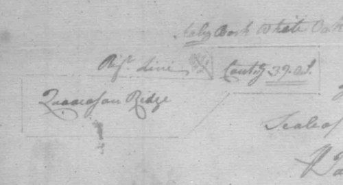
…all that Tract or parcell of land called Quaacoson Ridge scituate lying & being in Worcester County back in the Forrest bounded as follows Beginning at a marked scaley barkt white oak standing near the south end of a ridge known by the name of Quaacoson Ridge & a few miles back in the woods from Pocomake River on the West side thereof thence running South twenty poles thence West sixty six poles thence North thirty poles thence East fifty six poles thence North East forty poles thence East one hundred poles thence South thirty eight poles thence with a right line to the first bounder containing & now laid out for thirty nine acres of land more or less to be holden of the Manor of Worcester

Quaacoson Ridge, 1758

This admittedly vague description tells us a couple of important things:

  1. The tract was named after a geographical feature known as Quaacoson Ridge, and its first bounder stood near the southern end of the ridge.
  2. The tract and the ridge are located a few miles west of the Pocomoke River, placing them in today’s Wicomico County. Hogg Yard and Beach Ridge are located in the same neighborhood. (Of course, initially I couldn’t ignore out the possibility that they were located north of the Transpeninsular Line, in today’s Sussex County, Delaware, but that turned out not to be the case.)

A casual reading of other surveys associated with Isaac Mitchell, and then other families in the general neighborhood, including Wests and Whaleys, told me that the site is located in northeastern Wicomico County, relatively close to the state line. But there are quite a few points of high elevation in this area, and however well the name Quaacoson Ridge might have been known at one time, it doesn’t seem to have made it onto any maps.

Fortunately, a great deal of land in the neighborhood was patented to James Whaley in February 1850, and Quaacoson Ridge (the tract) turns up in these records. Even more fortunately, one tract in particular — West Level, which included land formerly surveyed for Henry Spears in 1770 — bordered the state line, making it relatively easy to place it and the adjoining tracts, including Quaacoson Ridge, on a modern map.

West Level, patented to James Whaley in 1850, incorporated elder tracts Spears Venture, Addition to Spears Venture, and portions of Quaacoson Ridge and Beach Ridge.

West Level, patented to James Whaley in 1850, incorporated elder tracts Spears Venture, Addition to Spears Venture, and portions of Quaacoson Ridge and Beach Ridge.

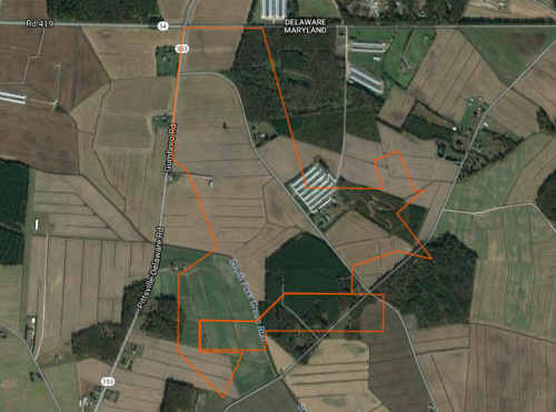
The following map was created with Plat Plotter, a free, fun, and very useful app that anyone can use to plot property boundaries. This is by no means exact, but it’s accurate enough for our purposes, i.e., locating the ridge for which the tract was named.

Approximate location of West Level and Quaacoson Ridge, plotted with Plat Plotter.

Approximate location of West Level and Quaacoson Ridge, plotted with Plat Plotter.

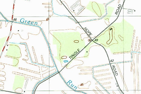
It would seem that the white oak which served as the first bounder of the tract stood on the northeast side of the waterway known as the South Fork Green Run (a curious name; South Fork of Green Run might be more accurate), but considering the likely margin of error, it’s not especially important which side of the branch the tree stood on. It’s obvious that it stood quite close to it, probably at the water’s edge. Although this point might not seem to be at the south end of a ridge, it does lie to the southwest of an area of slightly higher elevation, which would have been much more significant during the 1750s, when the land would have been much swampier. This feature, encompassing the intersection of Tingle Road and New Hope Road, is the most obvious candidate for the ridge due to its proximity and the fact that the tract includes a significant portion of it. Let’s call this feature Candidate A.

Candidate A. U.S. Geological Survey, 1992.

Candidate A. U.S. Geological Survey, 1992.

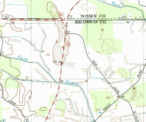
However, we must consider the possibility that the ridge is actually located a bit further away. After all, “near” is a very subjective term, and “near” in the context of a swampy forest in the 1750s might allow for a greater distance between the tree and the south end of the ridge than a modern researcher might assume. As it happens, the first bounder is, indeed, “near” — roughly 2,500 feet from — the south end of a much more prominent geographical feature which certainly seems very ridge-like. If this feature, which we’ll call Candidate B, was known as Quaacoson Ridge in the 1750s, one can see how a surveyor, lacking other landmarks, might reasonably have described the first bounder as lying near it (though why a tract would have been named after a ridge it didn’t actually touch is a mystery to me). One problem with this possibility is that other tracts associated with the feature in question, such as West’s Luck (which overlaps it), make no mention of Quaacoson Ridge. But they don’t mention any other ridge, either. Since West’s Luck bordered the state line and was surveyed in 1817, the surveyor might have felt that there was no reason to mention any other landmarks. Older tracts might include helpful references; further research is needed.

Candidate B, spanning the state line. U.S. Geological Survey, 1992.

Candidate B, spanning the state line. U.S. Geological Survey, 1992.

Wherever Quaacoson Ridge was, it’s clear that the name survived in some form into the early 20th century. When the new 14th election district was erected out of the 4th election district in 1906, its boundaries were described as follows:

Commencing at the Delaware and Maryland line at a point on the county road leading from Bethel Church to Whitesville, Delaware, about two hundred yars west of the residence where Enoch Truitt now resides; by and with the centre of said county road to interesect county road leading from Cobb’s Hill to James H. West road at or near Quackinson School House; by and with the centre of said road to intersect the county road known as the Radcliff Farlow road; by and with the center of said county road to old Burnt Mill known also as New Mill…

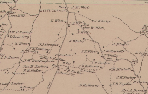
“Quackinson” is almost certainly a corruption of Quaacoson; Quackinson isn’t a local surname, and I can’t think of any other reason for such a name to appear in the neighborhood in question. The location of this school is a bit unclear. Two nearby schools appear on the 1877 Lake, Griffing, and Stephenson Atlas, unhelpfully labeled School No. 1 and School No. 2, but neither is especially close to the possible Quaacoson Ridge sites, and it’s unclear which, if either, was called Quackinson. A similar name, Quackison, appears in land records pertaining to Benton H. Whaley, dated 1899; a plat of lands known as Whaley’s Quarter depicts a road from Quackison to Pittsville intersecting with a road from Quackison to Cobb’s Hill.

The Quaacoson Ridge neighborhood, 1877,

The Quaacoson Ridge neighborhood, 1877.

Identifying Quaacoson Ridge would be a valuable contribution to local historical knowledge for several reasons:

  1. Place-names and specific sites associated with the local Indian tribes are relatively rare. Aside from a handful of settlements (mostly reservations) mentioned in late 17th to mid-18th-century sources, we don’t know of all that many specific places that were important to them.
  2. We know even less about Indian activities in this particular neighborhood, or in the neighborhood of the Pocomoke Swamp in general.
  3. Like us, Indians used relatively permanent routes to travel from one place to another. Locating such sites can help us to identify the routes used to get to them. Was there a path leading to Quaacoson Ridge? Could it be the basis of a modern road? Or — perhaps more likely — was the ridge reached by water?
  4. Determining the approximate location of Quaacoson Ridge contributes to our understanding of local Indian mortuary customs (or at least it raises more questions for us to attempt to answer). The site is far from any known Indian settlement, in one of the last neighborhoods to be developed by Europeans. Why? Did the local tribes always build quiacason houses on the outskirts of their societies, unlike others who are known to have built them in or near their villages? Or did the choice of location reflect a desire to conceal quiacason houses from the colonists, who had been known to damage or rob them on more than one occasion?
  5. The location of the ridge could also shed light on the origins of the local roofed grave custom. If Candidate B is Quaacoson Ridge, then it’s very likely that the ancestors or close relatives of John C. West (1814 – 1858), who was buried under a roofed grave near Trap Pond, lived on a ridge associated with Indian mortuary houses. That wouldn’t prove anything, but it would be very interesting. Even if Candidate A is the correct feature, it’s still close enough to the Bethel Church cemetery, as well as some of the oldest local West lands, to be related to the roofed grave custom.

– Chris Slavens

Leave a comment

Filed under Delmarva Geography, Maps, Maryland, Maryland history, Wicomico County, Worcester County