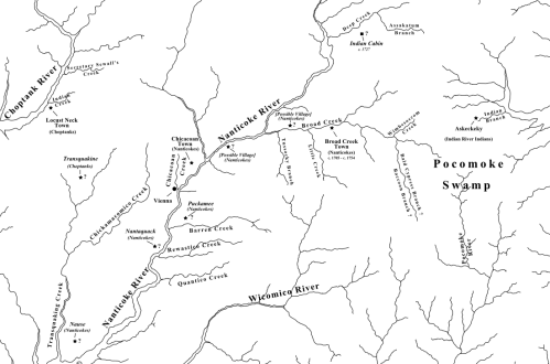
A few days ago I posted a draft of a map of the lower Delmarva Peninsula — portions of present-day Sussex, Dorchester, Wicomico, Worcester, and Somerset Counties — featuring villages and place names of the early 18th century. Although the locations of the Indian villages are approximate, and they may have been called by different names over the years, their existence is a matter of fact. Their names appear in colonial records, along with the names of nearby creeks and branches. We know when the reservations were established, who lived there, and about when they left. Some, but not all, appear on 18th-century maps.
The following map, though based on the same digital tracing of an old map of the peninsula, is a bit different. Locust Neck Town, Chicacoan Town, Broad Creek Town, and Askeckeky are still there, but I’ve added several sites that might have been home to Indian villages during or prior to the 17th century. Their names are italicized and I’ve placed question marks next to them. Just to be clear, there were many other villages. For example, in 1696 it was reported that there were at least ten Nanticoke villages, but I’ve shown the possible locations of only six. The text should be clear when viewed at full size.
Transquakine, also known as Ababco’s Town, was a Choptank village. I’ve placed it near the head of the Transquaking River, but I’m not at all certain about the location. It could be off by miles. The important thing is that there was such a village located in that general area. There were at least three Choptank villages during the 17th century.
Nause, a Nanticoke village, appears on John Smith’s map of Virginia, published in 1612. So does Nantaquack. I’ve tried to place them about where Smith placed them, but have no firsthand knowledge of either location.
Puckamee was the name of a neck of land on the north side of Barren Creek. In 1678, it was reported that Indians lived there; I assume they were Nanticokes.
I’ve placed possible village sites near present-day Sharptown and Bethel based on C. A. Weslager’s writings, but he was referring to archaeological evidence, not historical records, so there is no Nanticoke or English name for these sites. It’s possible that they were already old and abandoned by 1608. He thought that there was at least one village near Broad Creek when Smith traveled up the Nanticoke River. Based on all of the evidence I’m aware of, I can only guess that the village known as Broad Creek Town existed prior to 1705. Whether the Nanticokes reclaimed an old village, moved into an existing one, or established a new one at that time is unclear. It seems reasonable to assume that there were several villages and camps located along the creek and its branches during different eras prior to the arrival of Europeans.
Weslager also suggested, based on archaeological evidence, unexplained allusions in land records, and/or local folklore, that there were Nanticoke sites along Quantico Creek, Rewastico Creek, and Marshy Hope Creek. I haven’t looked into these locations yet, but might include them on a future draft of this map.
One of the most interesting sites is that of the “Indian Cabbin” mentioned in the 1720s. Indian Cabin Branch was a tributary of Deep Creek. Descriptions of an adjacent tract refer to Peterkin’s Branch and the Great Branch. According to Scharf, it was also known as Green Branch, and extended to Little Neck Branch. Unfortunately, none of these names appear on any map I’m familiar with, so I’ve simply placed the cabin near Deep Creek.
– Chris Slavens

