Tag Archives: Delaware history

Whorekill and Murderkill: Reclaiming Delaware’s Unsavory Place-names, part 2

In a previous post, I examined the English name Whorekill, which has been explained away as being a corruption of Hoorn (a Dutch city) + Kill (Dutch for creek), and concluded that the original Dutch name Hoeren-kil or Hoere kill most likely referred to whoring or prostitution on the part of the local Indian women, not the city of Hoorn. I also pointed out that the term hore could also be translated “mud” in Middle Dutch, the ancestor of the Dutch language spoken during the era in question.

A similar controversy surrounds the English name Murderkill, which is still in use today. The name dates back to the mid-17th century, when the Dutch and the Swedes had settlements along the Delaware River (then known as the Zuydt Rivier, or South River). Kill or kil meant creek, but the origin of the name Murder Creek is a bit more complicated.

Confusingly, the river and associated sites (e.g., a Quaker meeting house) were called both Murtherkill and Motherkill (sometimes substituting the suffix -kiln), murther being an archaic term for murder. This lends some credence to the theory that the Dutch originally named the creek Moeder Kill or Mother Creek, which has been advanced in the News Journal and elsewhere. The similarity between moeder and murder is undeniable, but I think the admittedly limited evidence suggests that the creek was named after murder (for whatever reason); therefore the English names Murtherkill and Murderkill are accurate successors, and it is Motherkill that was the corruption.

The earliest written form of the name comes from the Swedes. Peter Lindstrom’s map of New Sweden, generally agreed to date to the 1650s, includes a waterway labeled Mordare Kijhlen — or, in English, Murderer Creek. The name Moeder Kill or anything similar simply does not appear in any records of the time.

Published in 1691, Lindestrom's map is believed to date to the 1650s. Notice Hinlopen at the far left or southernmost portion of the map.

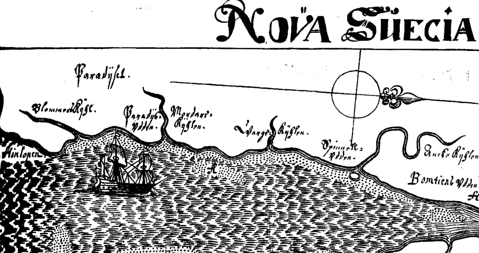
Published in 1691, Lindestrom’s map of the Delaware River is believed to date to the 1650s. Notice Cape Henlopen at the far left or southernmost portion of the map.

Following the English occupation of the territory in the 1660s, the name became Murther-kill, the English “murther” being an accurate translation of the Swedish mordar. This is the earliest English name for the waterway; Motherkill came later.

I believe it was the name and pronunciation of Murtherkill which gave birth to the alternative name Motherkill or Motherkiln. A number of traveling Quakers wrote of visiting the Motherkill or Motherkiln meeting during the mid- to late 1700s. Yet the names Murtherkill and Murderkill also appear in records of that era. Although I haven’t examined all of the sources in which the various names appear, based on those I’ve read it seems like locals and official records tended to use Murtherkill or Murderkill more often, which visiting preachers and the like may have misheard as Motherkill. For example, William Reckitt mentioned attending a meeting at Motherkill in 1758. In 1763, Daniel Stanton recorded the name as Mother-kiln, and in 1766, John Woolman spelled the name Motherkill. Job Scott recorded the name Mother-kill as late as 1790, yet the local abolitionist Warner Mifflin mentioned the Murtherkill Meeting in 1797. Generally speaking, the creek or river tended to be called Murderkill more often than the other variations during this period, and it is this name that survives to this day.

As to why the Dutch and/or Swedes named a creek after murder or murderers, vague legends involving a massacre of the local Indians have surfaced in sources of questionable reliability, but even the earliest references to these legends seem highly speculative, and were perhaps more an attempt to explain an odd name than to preserve genuine traditions. The possible stories behind both Murderkill and Whorekill might be worthy of a future post or two.

– Chris Slavens

Leave a comment

Filed under Delaware, Delaware history, Delmarva Geography

Additions to the bookshelf, and a shout-out

A few days ago I received a surprise gift from my brother: Copies of A Brief Account of the Indians of Delaware by C. A. Weslager, and History of Lewes, Delaware, and Vicinity by Virginia Cullen, which he stumbled upon in an upstate antique shop.

The former is a 31-page pamphlet published for younger readers in 1953, but this is no vague, babyish text about wigwams. Even two decades after his death, Weslager remains the authority on the original Delawareans, and this early work not only paints a picture of their daily lives, but includes specifics about different tribes, including the locations of some of their villages.

A Brief Account of the Indians of Delaware, Weslager

The book about Lewes is a bit longer, 78 pages, and was published by the Daughters of the American Revolution in 1956. The format reminds me of another local history book, Folklore of Sussex County, Delaware by Dorothy Pepper, with sections of a few paragraphs or less featuring a particular era, individual, landmark, etc. The book includes local folklore, and concludes with a guided tour of the community with information about numerous historic buildings.

History of Lewes, Delaware, and Vicinity

Both are the sorts of books that one typically finds in noncirculating collections in local libraries. Many of Weslager’s books, in particular, can be very difficult to find, and are treasured by collectors.

While I’m at it, I’d like to give a brief shout-out to Mitsawokett, probably the best online source of information about Native Americans in Delaware from prehistoric times through the present. The site features information ranging from casual speculation to authoritative primary sources, and links to numerous other sites of interest. Someone recently added a couple of my articles about the Nanticoke Indians, causing Mitsawokett to become the top referrer of visitors to this blog (discounting search engines and social media), which I greatly appreciate.

– Chris Slavens

Leave a comment

Filed under Books, Delaware, Delaware history, Sussex County

Will of Teague Matthews, Jr., of Sussex County, 1790

The following is a possibly imperfect transcription of the last will and testament of Teague Matthews, Jr., a native of Somerset County who seems to have moved to the Broad Creek area in the 1770s. He and his wife, Mary Truitt, had several children, from whom many of the Matthews of Sussex County are descended; their descendants also include members of the Vinson, Hitchens, Cannon, Messick, and Lewis families, among others. Teague lived on the outskirts of what was then known as the Pocomoke Swamp, on the east side of Wimbesoccom Creek (Gray’s Branch), and attended the recently completed Broad Creek Chapel (Old Christ Church). He died in the spring of 1790. It’s unclear whether he was buried at Broad Creek Chapel or on his own land; wooden grave markers have been found at both locations.

I’m working on a longer article about the Matthews family and their fascinating, overgrown family cemetery several miles east of Laurel, but in the meantime, here’s the text of the will for genealogists or anyone else who might be interested:

Will of Teague Matthews

In the Name of God Amen
I Teague Matthews of the County of Sussex and State of Delaware [planter?] being low and weak of body but of sound and perfect mind and memory, thanks be to God for it, and calling to mind the uncertainty of all human events, and that it is appointed unto all Men once to die I have thought proper to make and ordain this my Last Will and Testament, hereby disannulling and making void all other Will and Wills by me heretofore made in manner and form following. I give and bequeath unto Almighty God that gave it, my Immortal Soul, as for my body I desire it may be decently buried at the discretion of my Executors hereafter named; as for the Worldly Goods wherewith it have pleased God to endow me I give and bequeath in manner and form following…

I give unto my beloved Wife Mary Matthews the place I bought of John Jones, with all the Improvements thereunto belonging during her natural life of Widowhood, and I order that she shall not be in anywise disturbed in the use of my present dwelling houses untill she either dies, marries or my Son Phillip builds her a House, on the said place called Jones’s place, the House to be framed, eighteen feet by twenty a Brick Chimney and reasonable furnished: also I give unto my said Wife One yoke of Oxen, one black Colt, one Bed and furniture, one Ewe and Lamb, one Cow and Calf.

I give unto my Son Phillip my home plantation together with all the Improvements, thereunto belonging to him and his Heirs for ever, but my desire is that if he dispossesses of the said Lands and without lawful Heirs that he should leave it to my Son David. I also give unto my Son Phillip One Bay Mare, also one Bed and furniture also two Bull yearlings…

I give unto my Son James all the Lands that I bought of John Jones, together with all the Improvements thereunto belonging after the death or Marriage of my Wife, to him and his Heirs for ever…

I give my daughter Betty Vinson One Cow and Calf and one Ewe and Lamb more than she has already had from me…
I give unto my daughter Sally, One Cow and Calf, one Spinning Wheel, one pine Chest that she calls hers, one Bed and furniture, and One Ewe and Lamb…

I give unto my daughter Rebecca, One Bed and furniture, one Cow and Calf, one Chest that I formerly called mine and one Ewe and Lamb…

As for all the remainder of my moveable Estate I order that it may be equally divided between my Son James, my Son David, my Son Levi, my daughter Catharine and my daughter Prissa, and my desire is that the whole may be done in a quiet and peaceable manner. And I hereby leave my beloved Wife Mary Matthews and my Son Phillip Matthews, joint Executors of this my Last Will and Testament, In Witness whereof I have hereunto set my hand and Seal this twenty third day of March. One thousand Seven hundred and Ninety.

Signed Sealed and delivered as the Testators Last Will and Testament being first duly published and pronounced in the presence of us Thos Conner. Molly Roach. Rebecca Conner.

Teague (his X mark) Matthews

Memorandum this 27. Day of April 1790 before me Phillips Kollock Register appointed for the probate of Wills and granting Letters of Administration for the County afsd. Appeared Thomas Connor and Rebecca Connor, two of the Witnesses to this foregoing Will, who being duly sworn on the Holy Evangels of Almighty God did severally depose and say that in their sight presence and hearing the Testator Teague Mathews did sign Seal publish and declare the same to be his Last Will and Testament, and that at the doing thereof he was of a sound and perfect mind memory and Judgment and that they and each of them together with Molly Roach subscribed the same as Witnesses in presence of the Testator and at his request. Phillips Kollock Reg.

– Chris Slavens

Leave a comment

Filed under Laurel, Sussex County

Delaware Thanksgiving Proclamation, 1858

In the name and by the authority of the State of Delaware, Peter F. Causey, Governor of the said State:

Fellow citizens:

It is but a just tribute of a grateful people to offer thanks to an Almighty Providence for the many and signal blessings which have been extended to them and for the watchful care which has guarded and protected them as a nation.

Our people and nation are among the most favored of the earth, in many respects we are the “peculiar people” of God’s Providence; liberty in its best and truest sense is the inheritance of every citizen, and our growth and progress are without a parallel in the history of the world; flourishing towns and villages now stand where but a short time since the wilderness held undisputed sway; and the noise of machinery and the hum of industry have displaced the silence of the forest — older nations are astonished at our rapid advancement and we are already recognized and respected as one of the most important powers of the earth.

Amid the blessings which have so signally marked the progress of our common country, our own State has received her share; pestilence and famine are unknown within her borders;a bountiful return repays the labor of the husbandman; our people are contended, prosperous and happy. In view of these blessings, and in conformity with established usage and the wishes of many citizens,

I, Peter F. Causey, Governor of the State of Delaware, do hereby recommend Thursday, the twenty-fifth instant, as a day of General Thanksgiving and Praise throughout the State, and request the people, that, abstaining from all worldly occupations, they assemble in their respective places of worship, and give most humble and hearty thanks to Him who holds in his hand the destinies of nations as of individuals.

Given under my hand and the great seal of the State of Delaware, at Dover, this ninth day of November, in the year of our Lord one thousand eight hundred and fifty-eight, and of the Independence of the said State, the eighty-third.

P. F. Causey

By the Governor.
J. R. Lofland, Secretary of State.


Peter F. Causey was a native of Bridgeville, a Methodist, and a prohibitionist who was elected governor on the American Party ticket.

Peter F. Causey was a native of Bridgeville, a Methodist, and a prohibitionist who was elected governor on the American Party ticket.

– Chris Slavens

Leave a comment

Filed under Delaware, Delaware history

Road research, part 1: Broad Creek to Indian River

18th-century maps of the Delmarva Peninsula are frustratingly short on details when it comes to roads. The major routes are depicted, of course, like the well-known stage road from Salisbury to Laurel Town, but when it comes to some of the minor routes alluded to in land surveys from the first half of the century, researchers are left guessing. Waterways are usually the best geographical features to use as reference points, being more or less stationary and often (but not always) retaining their colonial-era names, but many of those ancient footpaths and roads still exist under the paved surfaces of modern highways. It’s just a matter of figuring out which ones.

One such colonial road of uncertain location is mentioned in the description of a tract surveyed for Philip Wingate in 1748: “…Beginning at a markd white oke standing on ye north side of Broad Creek about three miles back in ye woods & on ye north side of a horse Rode leading from ye aforsd Broad Creek to ye Indian River…”

As I don’t know exactly where Wingate’s land was located (“ye north side of Broad Creek” is a rather large area), I’m only speculating, but this so-called horse road may have originally linked the Nanticoke reservation known as Broad Creek Town and the Indian River Indian reservation known as Askecksy (among other, similar names), both of which were settled as early as 1705. The town of Laurel now occupies the site of Broad Creek Town, while Askecksy was located south of present-day Millsboro, near Injun Town Road or Indian Town Road.  It is known that the residents of these Indian towns had settled there to escape English encroachment, and had contact with each other, despite belonging to different tribes; in 1742, they met in the area roughly between the two reservations known as Winnasoccum or Wimbesoccom, and planned to attack the local English settlers, as explained here. Shortly thereafter, the Indian River Indians sold their land, and most of the Nanticokes migrated to Pennsylvania. By 1748, the road in question may have been used almost exclusively by the English, and may have led directly to the mills located near the branches of Indian River, rather than the old Indian lands located a few miles south of them.

I’ve crudely spliced together maps of Broad Creek Hundred and Dagsborough Hundred from the Pomeroy & Beers Atlas of 1868, which was the first map of the area to show its extensive network of unpaved roads, and highlighted the route that the horse road of 1748 may have followed. Eventually I’d like to complete a map of the entire area as it looked during the colonial era, but for now, this rough mash-up is better than nothing.

Beers, edited

– Chris Slavens

1 Comment

Filed under Indian River Indians, Maps, Nanticoke Indians, Sussex County